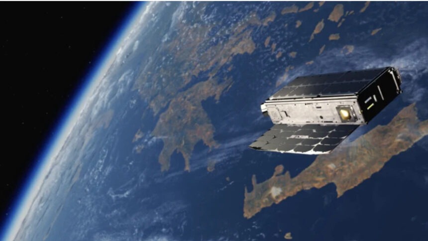
Four thermal imaging satelites will be used to track wildfires and other extreme heat phenomena compounded by climate change.
A SpaceX Falcon 9 rocket launched the satellites from Vandenberg Space Force Base in California earlier this year. These satellites have been designed to detect and monitor wildfires in near-real time, providing details about the fires’ progress, detecting any remaining active spots and documenting the damage.
These satellites, and others that make up Greece’s satellite fleet are part of the National Microsatellite Program that support the collection and management of satellite data and have place Greece on the vanguard of using satellite systems to fight wildfires.
The satellites were designed, and their operating system developed, by a consortium led by Munich-based OroraTech, referred to on its website as “the global leader in space-based thermal intelligence” which won a competitive bid.
“OroraTech was awarded a €20 million development contract in 2024 to build and launch Greece’s first national wildfire monitoring system. The system includes four dedicated thermal imaging satellites and a robust data processing and alerting infrastructure. As part of that mission, OroraTech committed to local hiring, workforce training, and the establishment of a permanent operational presence in Athens,” the company said in April 2025.
The thermal imaging satellites use infrared technology “to detect even small fires before they developed into big fire fronts” according to Professor Konstantinos Karkantzalos, Secretary General of Telecommunications and Posts at the Ministry of Digital Governance.
“Data crunching and fire detection take place on the satellite, to ensure immediate reporting to the (firefighting) operational center. At the same time, maps are produced predicting how the fire will develop based on the focal point, the lay of the land, the type of vegetation, humidity and other weather data,” he added.
Ioannis Lantouris, managing director of OroraTech Greece adds that the satellites scan all of Greece’s territory, taking temperatures in order to detect thermal anomalies. “This scanning is literally done pixel by pixel,” he says.
Some times, the thermal spike is a false positive, caused, for example, by solar panels reflecting sunlight, factory chimney fires and buildings with tin sheet roofs that raise temperatures. But “the models we use can distinguish (between those cases) and a real fire,” Lantouris assures.
For the time being, it takes about half an hour for the information to be sent to the Civil Protection datas platform, processes with the help of Artificial Intelligence and result in sounding the alarm. The goal is to limit this delay to five minutes in the coming years, Lantouris says.
Satellite data help threefold: the timely detection of fire outbreaks, iun combination with drones and other visual data; operational response, with a real-time, dynamic mapping of the fire fronts and predictive capabilities as to their development; and post-fire estimation of damages to support compensation, reforesting and other measures, said Karkantzalos.
Greece is the only European country that has invested in a national thermal imnaging satellite system and has set it in orbit.
The infrared thermal cameras installed in these low-orbit satellites can also be used on other issues affecting the environment, agriculture and water resource. “We can use thermal and optical data to detect crop stress (and) the level of water tables,” he says, also using other satellites not specifically built to detect fires. They can also help detect floods and rockfalls.
Source: Ekathimerini.com


Leave a comment